Overhead 3D LiDAR mapping image.

Zoom in on climate change mitigation

Reveal a new perspective on climate mitigation with LiDAR technology. Like a powerful lens, our program gives clear and actionable insights into the vital environmental data you need to make effective decisions. From wildfire risks to flood mapping and resource management, you can broaden your knowledge in a few weeks and step into a role where your skills contribute to climate change mitigation.

Invest in your future and become part of the solution for positive change in your field and community.

Jump to:

Program description

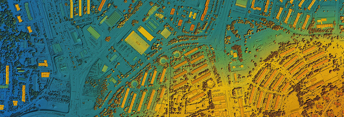
The Micro-certificate in LiDAR Fundamentals for Climate Change Risk Analysis will equip students to use and analyze LiDAR data. Using remote sensing survey data via LiDAR, students will gain skills to analyze wildfire risk, mining, flood mapping, coastal zone conservation, agriculture, urban development, transportation and other industries. This will allow students to make more informed and effective decisions or policies regarding resource management, conservation and planning in the face of climate change.

Designed to enhance introductory education in geography, geomatics or GIS, this program will deliver a curriculum unique within British Columbia through a blend of theory and competency-based skills developed with leading sector experts and practitioners. Students will complete a six-week online course totalling 36 hours.

Assessments include the interpretation of provincial LiDAR data and images and will be hands-on and applicable to real-world use, allowing for immediate transition from the classroom to professional workplace integration. Learners will be able to directly address current issues and challenges relevant to their sector by using industry-specific LiDAR data.

Program highlights


Computer icon
Online Flexibility
This program is delivered online, allowing you to work independently within deadlines set by your instructor. With this format, you don't have to worry about travel or scheduling conflicts while you study. You can work at your own pace, on your own schedule and maintain a balanced lifestyle. 

Credential icon
Credibility
The University of Victoria is one of Canada's leading universities, recognized for preparing students for careers in a wide range of disciplines. Upon successful completion of this program you will receive a micro-certificate.

Icon of a hand clutching a pencil
Manageable
Our LiDAR Fundamentals for Climate Change Risk Analysis program is designed with a busy lifestyle in mind. Learn at your own pace, set personal deadlines and propel your career journey forward.

Icon of a calendar
Short-term
This program is designed to provide you with the knowledge and tools necessary to achieve your professional goals in just six weeks.

Instructor icon
Teaching Talent
Our instructors are industry professionals with years of experience. They’re dedicated to helping you develop the knowledge and skills to realize your full potential.

Program partner

The University of Victoria logo

Faculty of Social Sciences, Department of Geography

Program outcomes

Learners who complete the LiDAR Fundamentals for Climate Change Risk Analysis micro-certificate will be able to:

  • understand the application of LiDAR climate change mitigation
  • interpret provincially-accessible airborne LiDAR data
  • use LiDAR to communicate information about climate change impacts and mitigation planning
  • use LiDAR data to address resource issues across multiple industries
  • interpret LiDAR data and integrate it with other geospatial data products

Who is this program for?

The LiDAR Fundamentals for Climate Change Risk Analysis micro-certificate is designed for entry-level or mid-career professionals—with a background in geography, geomatics, GIS, environmental science or related fields—who are looking to add relevant skills to their toolkit.

If you see yourself reflected in any of the following, this program could be a good match: 

  • you are passionate about environmental sustainability, climate change mitigation or advanced technology in data analysis
  • you have a strong commitment to conservation, resource management and using technology for positive environmental impact
  • you want to enhance your skills and knowledge for career advancement, and make a tangible difference in climate change mitigation efforts
  • you proactively seek professional development opportunities, value hands-on and practical learning experiences, and are tech-savvy with a preference for online and flexible learning formats

Career options

Some of our learners pursue careers in the following roles:
  • Remote Sensing Technician
  • GIS Specialist/Technician
  • LiDAR Data Analyst
  • Geospatial Analyst
  • Environmental Consultant
  • Climate Change Analyst

Application and fees

To successfully complete the Micro-certificate in LiDAR Fundamentals for Climate Change Risk Analysis, participants must complete the course below.

Admission requirements

Students in the LiDAR Fundamentals for Climate Change Risk Analysis micro-certificate program must meet UVic admission requirements, including the English language proficiency requirement.

How to apply

No application is necessary, simply select the course required for the micro-certificate and register for it independently. When registering, you will have the option to purchase the Micro-certificate in LiDAR Fundamentals for Climate Change Risk Analysis fee at an additional cost of $20.

Once you have completed the course, your certificate will be automatically issued and sent to you. Certificates will be sent approximately one month after the completion of your course.

Note: We are unable to retroactively issue a micro-certificate. Students must purchase the $20 program fee prior to the last day of the last course in the program.

Registration details

You have already registered for this course.

View My account

This item is already in your shop cart.

View shop cart
Loading section fee(s)...

You're already on the waiting list for this item.

Sorry, this section is full.

FEES

Fee Tax Subtotal
{{ ::(fee.price | currency) }} {{ ::(fee.tax | currency) }} {{ ::(fee.total | currency) }}
{{ ::(child.price | currency) }} {{ ::(child.tax | currency) }} {{ ::(child.total | currency) }}
    Total {{ fee.totalFees | currency }}

Add to Shop Cart Loading

Note: You will be asked to sign in or create an account to register and pay for this course.

Having trouble registering online? Register by phone: 250-472-4747

Online registration temporarily unavailable

Sorry, this course is not available for registration at this time.

This course is in progress. Please contact us for more details.

Online registration is closed for this course. You may still be able to register by phone. Call 250-472-4747 to find out.

This course is on your wish list. You will be notified when this course becomes available.

Want to receive notification when this course becomes available?

{{ loggedIn ? 'Add to wish list' : 'Sign in/create a new account to add to wish list' }}

Info you should know:

Continuing Studies statement on use of educational technology

This course will require the use of Zoom and may use other education technology such as internet-based applications, cloud services, or social media. In order to complete this course you will be required to either consent to the disclosure of your personal information outside of Canada to enable use of these technologies, or work with the Division of Continuing Studies to explore other privacy protective options (such as using an alias or nickname).