
Programs

Amateur Landscape and Garden Design
This micro-credential program will help you master landscape and garden design skills in just 16 weeks. You’ll gain the hands-on knowledge and practice you need to create the yard and garden of your dreams.
Read More
Climate Action Planning
The Climate Action Planning micro-credential (CAP) is a great opportunity to learn the foundations of planning for climate action. You will develop the skills needed for you as a professional to put into action at all government levels.
Read More
Climate Activism
The Climate Activism program provides climate activists with the skills and knowledge to build practices for organizing transformational change.
Read More
Community Fishers Training
Community Fishers is an advanced solution using state‐of‐the‐art technology that provides a practical, user‐friendly tool for collecting data from mobile scientific instruments, which can then be managed and freely accessed via Ocean Networks Canada’s world‐leading oceanographic data management system, Oceans 2.0.
Read More
Ecological Restoration
Advanced ecology training that builds on your knowledge in the field. Courses are offered online, appealing to working professionals as a means to meet their annual professional development requirements or to update their skills and understanding.
Read More
Fire Ecology for Environmental Restoration
The Fire Ecology for Environmental Restoration program equips learners with practical knowledge to understand and treat the effects of fire on natural ecosystems.
Read More
GIS Skills and Mapping
GIS technology is increasingly integrated into various industries to enhance spatial data analysis, decision-making, and planning capabilities. The program provides hands-on training in open-source software like QGIS, Google Earth and the Gaia app. You will learn to create custom maps, analyze spatial data, and answer complex human and environmental questions.
Read More
Green Shores™ Training
Open to homeowners and shoreline professionals, these one- and two-day workshops provide information about the Green Shores program, including its rationale, benefits and application.
Read More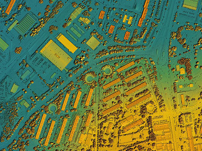
LiDAR Fundamentals for Climate Change Risk Analysis
LiDAR is a remote sensing survey method that facilitates 3D mapping of the Earth’s surface including urban and rural topography. This program equips learners to use and analyze LiDAR data for developing critical information towards mitigating the impacts of climate change.
Read More
Mapping with Drones
Do you want to take your connection to our planet to new heights? Flying drones gives you the chance to navigate the Earth from above and reach new perspectives like never before.
Read More
Ocean Acoustic Monitoring
Ocean acoustic monitoring empowers community members to easily contribute high-quality, continuous data on noise levels to help better understand and inform policy on the changes that may be impacting the ocean environment over time.
Read More
Politics, Policy and Climate Action
The Politics, Policy and Climate Action micro-certificate will provide insight into the policy and political contexts that shape climate action across scales from local to global, including relevant institutional and governance innovations.
Read More
Practical Leadership for Technology and Engineering
This program is designed for professionals in technical fields aiming to enhance their leadership soft skills. It covers essential leadership foundations tailored to technology, engineering and geomatics contexts including active listening, effective management, team-building and conflict resolution.
Read More
Restoration of Natural Systems – Certificate
Knowing where we are headed, from an ecological standpoint, requires an understanding of environmental impacts and recovery strategies. The Restoration of Natural Systems program provides a bridge that connects this knowledge with the practical skills needed to solve complex restoration issues.
Read More
Restoration of Natural Systems – Diploma
The Restoration of Natural Systems program provides a bridge that connects this knowledge with the practical skills needed to solve complex restoration issues. The program’s holistic approach will empower you, as someone who is passionate about the environment, to make a difference in how we connect with the natural world.
Read MoreRNS Student Resources
This page contains links to resources that will support your learning in the Restoration of Natural Systems Program.
Read More
Tourism Sustainability
This micro-certificate addresses the response to extreme weather events and the global need for climate change mitigation and adaption. The program aims to prepare learners with the tools and knowledge to navigate environmental challenges in the tourism sector.
Read More
Transformative Climate Action
The need for transformative climate action is urgent. An effective and practical response requires significant changes to how we live. The Transformative Climate Action Certificate (TCA) provides the tools needed to make social, cultural and political changes that support diverse, ethical and flourishing communities.
Read More